|
|
|
|
Sponsored By:
 |
|
 |
Real estate agent puts MLS listings on Google Earth
Integration includes county data of for-sale homes
Friday, April 28, 2006
By Glenn
Roberts Jr.
Inman News
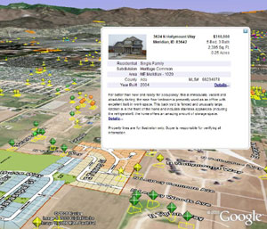 Earth Point screenshot
|
Google Earth put the world – at least a computerized
version of it – at computer users' fingertips, and a real
estate agent in Idaho has put a new spin on property listings
by sprinkling local MLS data on this digital globe.
Bill Clark, an agent at Holland Realty in Boise, unified
county property records and multiple listing service
information and packaged this data for display on the Google
Earth application. Google Earth allows users to zoom in and out
on a map and to rotate and tilt the map view. In order to view
property listings, computer users must first install Google
Earth, a free program, and then download property listings
from Clark's Earth Point Web site, at http://www.earthpoint.us/.
Properties are color-coded by price, and listings that
appeared on the local MLS within the past week are represented
with a star-shaped symbol while other properties are
represented by a diamond-shaped symbol. The Google Earth
representation of the MLS properties shows parcel outlines,
based on county records, and users can click on property icons
for property descriptions and photos.
Clark said he worked on the project for about eight months,
and the Google Earth-based MLS search capability launched
about two months ago. The property listings information is
supplied by the Intermountain MLS in Boise, the largest MLS in
the state.
There are about 4,000 property listings in Ada and Canyon
counties available for viewing via Clark's Google Earth
integration, including about 3,200 listings of homes for sale.
The property listings are updated daily, he said.
Flyover views are nothing new for Clark, who has maintained
a pilot's license since high school and developed a private
residential airport with his neighbors. Even so, he said he
was dazzled when he first saw the Google Earth tool, which
allows viewers to zoom in on any part of the planet – from
outer space to a rooftop view. "I saw Google Earth and I just
said, 'Holy cow,'" he said.
There are a handful of other real estate-related companies
that have offered property listings data for the Google Earth
site – Point2, Propsmart.com and ForSaleByOwnerCenter.com are among those that
have announced Google Earth integration.
A larger group of real estate sites are using the Google
Maps-based platform to display property listings. There are
other pluses and minuses to each mapping tool: Google Earth
views offer added dimension and customization compared to
Google Maps, while Google Maps is a streamlined and simplified
mapping tool that operates in a Web browser and doesn't
require a data download.
In March, the author of the Google Earth Blog promoted Clark's
work, which he said "shows more information, and with more
accuracy, than any other real estate listing service I've seen
to date."
Greg Manship, director for the Intermountain MLS, said he
isn't sure whether a lot of real estate agents in the area are
using Clark's tool, though he is familiar with the technology.
"He came over and gave us a demo," Manship said. "I've talked
to Bill quite a lot about the concept. It's expanding on the
IDX data using new technologies that are available."
Another company in the area, Genius
Realty, is displaying the MLS data in a Google Maps format
at its Web site. Heinrich Wiebe, a manager at Genius Realty,
said the company's mapping tool launched about two months ago
and is popular with consumers. "Our position is – give them
the data," he said.
Heinrich and co-manager Matt Newbill said they are familiar
with Clark's Google Earth integration. "It's pretty complex
for just your typical end-user," Newbill said. "People are
pretty impatient when they're on the Web. The less hoops the
better. We don't require logins or passwords to get the data –
it's just come and get it."
He also said that consumers are empowered by new
property-search tools. "It used to be that only the real
estate agents held the data. They are no longer held
hostage."
Clark said that his Google Earth integration is a useful
tool for listings presentations, and he believes there is a
rich future for real estate-related mapping applications. "I'm
convinced this is going to be successful and grow. I think in
a couple years this will be the standard," he said.
There is a huge community of developers who are building
integrations with Google Earth for other purposes, he said,
such as map locators for speed-monitoring cameras on European
roads and for National Geographic feature articles. "That gave
me enough confidence to say there are enough people who – when
they see this – they're not going to go anywhere else. Once
you have a customer using this they're not going to go back to
the old method," Clark said.
"What makes Earth Point special ... is that you use the map
itself to hunt for property. Thus, Google Earth becomes the
primary interface to the MLS," he said. By contrast, some
traditional property-search sites use maps as a secondary
source for finding properties, he said.
With those sites, he said, "you enter search criteria on
the screen, get this list, and say, 'Well, that's interesting,
I wonder where that is," and then map this property. (Mapping)
is the last step of your process. Google Earth is the other
way around – you can just go hunting like you're in a
helicopter. I think it's making it a lot easier to wade
through all that data."
The Earth Point project has been rewarding, though it was
"a long road" to get it off the ground. It took him about four
or five months of work before his first success in getting
properties to show up on Google Earth. "When I saw that first
dot show up on the map ... I just fell over. That was
gratifying. It was a huge challenge. It took me three months
to that 'Yes, it really would work.' When I started out there
was no one to turn to."
Before he took on the project, Clark worked in the
manufacturing industry, and the challenge of integrating
property data with Google Earth drew upon his interests in
computer programming, mathematics and navigation. "I have
flown several times across the U.S. using just a watch and a
compass for navigation ... and have done weeklong treks in the
Idaho wilderness with even less," he said.
Clark said he would like to add a new layer of information
to his Google Earth integration, such as museums and other
public attractions. He has also considered mapping local
garage sales.
In addition to existing properties, Clark has mapped
several new housing developments on Google Earth using
developers' subdivision maps. In the future, he said he would
consider charging a fee to promote new developments using
Google Earth. "The master plan would appear, along with a
description of amenities and a link to the subdivision Web
site," he said. "Once construction is under way, the links
would be geared to the home buyer. They could learn more about
the house being built, available options, history of the
builder, etc. All this would happen well before anything
appeared on the MLS."
***
Send tips or a Letter to the Editor to [email protected] or call
(510) 658-9252, ext. 137.
Copyright 2006 Inman News |