|
County GIS - show all property in Ada and Canyon counties, Idaho.
A user account is not needed
for the features on this web page.
|
|
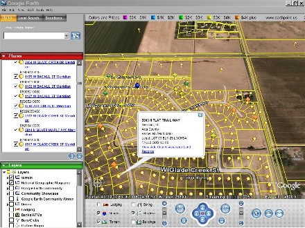
Click for larger image.
|
If you are looking for property for sale, please go to the Listings
page. This page maps county assessor data for all properties in Ada and Canyon
counties, Idaho. As you move around in Google Earth, the property boundaries
are drawn for everything on the screen. Click on each property to see the
county assessor data. To keep the data transfer size reasonable, Earth Point
will not send data if there are more than 1500 properties displayed on the screen.
If that happens, zoom in closer.
Options
Hint
If you know the address of the property you are looking for, try the
Land Records Search page.
Data
Ada County data published January 12, 2015. Canyon County data published June 25, 2014. Earth Point gets new data every twelve months.
Hints
Click the "View" button just once. The screen is updated as you move around in Google
Earth. You must be zoomed into the Boise, Idaho area (anywhere over Ada or Canyon
county) to see the data.
Try This
Download both the County GIS and the property listings. Now you can see the
property makeup in any area of interest. This is particularly useful in new
subdivisions that are not yet on the Google Earth imagery. With the GIS download,
the location of all the houses and streets is readily apparent.
Only Download one County GIS at a time
Otherwise, you will have three or four County GIS' updating themselves every time
you move around in Google Earth.
|