Texas Land Survey on Google Earth.
A subscription is recommended for the features on this web page.
more
|
|
Click for larger image.
|
|
|
You are not signed in to your account. Texas Land Survey will display a pop-up message
every ten minutes and will be deactivated after one day. For unrestricted access,
please
sign in
or purchase
a subscription. You must have Google
Earth installed to use this data.
|
Help:
How to
install Texas Land Survey.
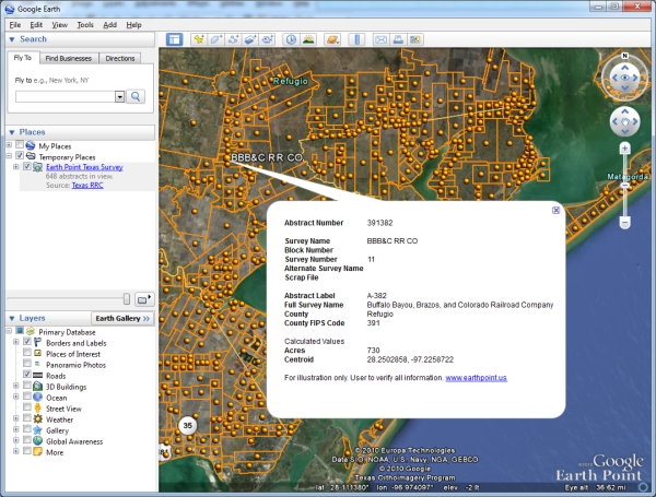
This page maps the Texas Land Survey onto Google Earth. Texas does not use
the Public Land Survey System. Texas has its own survey based on original
Spanish Land Grants. You must zoom over Texas, USA in order to see the data.
The data shows Texas Abstracts. It does not show individual properties or parcels.
Information: Texas Land Survey
An interpretation of the Original Texas Land Surveys boundaries and bay tracts.
The dataset was derived from the Texas General Land Office (GLO) county maps, the
GLO Abstract of Original Land Titles:Volumes and Supplements, and the GLO maps of
State-Owned Submerged Lands of the Texas Gulf Coast (bay tracts). The GLO county
maps, showing the boundaries of the original land grants of the State of Texas,
were compiled and drawn by GLO draftsmen. This dataset is a digital interpretation
of the geographic placement of the original land grants and bay area tracts depicted
on these GLO maps and is not a legal survey product.
Link -
http://www.rrc.state.tx.us
DISCLAIMER:
This dataset is NOT intended to be used as an authoritative public record for any
geographic location or as a legal document and has no legal force or effect. Users
are responsible for checking the accuracy, completeness, currency and/or suitability
of this data. The Railroad Commission makes no representation, guarantee or warranty
as to the accuracy, completeness, currency, or suitability of this data, which is
provided "AS IS".